The application of the Tabas region to the council of World Geoparks has received a positive answer from the UNESCO committee.
Tabas, known as the bride of the desert, could become Iran’s next geopark, after Qeshm island. A recognition that will help to preserve and highlight the exceptional natural and geological features of this region.
Contents
Tabas, a land between desert and mountains
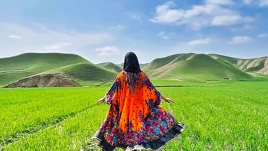
Tabas is a region located in the eastern province ofn South Khorassan (east of Iran). Nicknamed “the bride of the desert”, it is a mountainous desert area, part of the great Dasht-e Kavir desert. Usually absent from the classic routes to visit Iran, Tabas is still a hidden gem. This could change soon as Tabas could benefit from all the attention it deserves by becoming a UNESCO geopark.
In 2011, and after years of initial studies to identify various sites and name them, local authorities applied to register Tabas as a UNESCO geopark. In December 2022, the Supreme Council of World Geoparks of UNESCO has given a positive vote to this application. It means that Tabas could be officially registered on the list of UNESCO geoparks next year. It would then become the biggest one in West Asia and Iran’s second geopark, after Qeshm island.

But what is exactly a geopark?
UNESCO defines geoparks as “single, unified geographical areas where sites and landscapes of international geological significance are managed with a holistic concept of protection, education and sustainable development”. There are currently 117 UNESCO geoparks around the world, in 46 countries.
There are many advantages of being registered as UNESCO geopark. Being part of this network gives the opportunity to preserve unique landscapes and encourage sustainable development. As it brings light to a specific region, a UNESCO geopark also participates in socio-economic development and increases tourism, while raising awareness of geohazards. This status is also a guarantee regarding the preservation of natural and cultural heritage.
Tabas’ unique geosites and attractions
Not well-known to visitors, Tabas has a huge touristic potential due to its exceptional landscapes. Whether it’s canyons, waterfalls, rice fields, deserts, old caravansaries, or ancient cities, 50 sites have been identified to become geosites.
Geological geosites
Tabas has a huge number of significant geological sites. They can be classified under several categories.
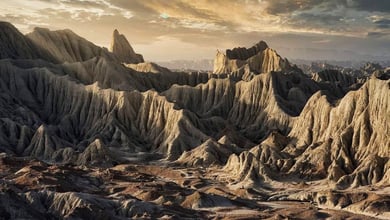
Among the most interesting geological sites are first valleys, or canyons:
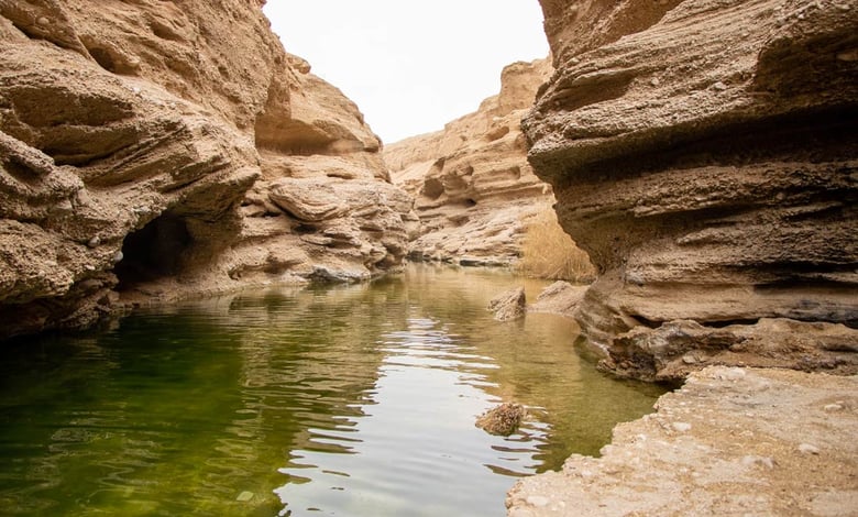
Kal-e Jenni is the major valley of Tabas, located in Armighan village. It has a length of 9 kilometers and its height can exceed 40 meters in plain, and up to 100 meters in the mountain parts.

Kal-e Sardar is another beautiful valley. Besides its fabulous landscape, it also has cold and hot springs, rivers, angular unconformity but also petroglyphs and historical sites such as the Ghulat fort.
Kal-e Tafto is another valley that reaches up to 300 meters and has rivers and springs. Because of this, it has a very green landscape with a great variety of plants, which is unique in such desert landscape.
Among the geosites, several are desert areas:
Rig-e Shotoran is located on the southern part of Dasht-e Kavir, Iran’s middle plateau, and is one of the most important sandy areas of Iran (it covers 2500 km2)
Parvadeh has 100 km2 of sand dunes with various forms, some at more than 70 meters above ground level.
Dasht-e Kavir Salt Polygons is the largest salt playa in the world, covering 60.000 km2. During the rainy season, this area is particularly beautiful due to the seasonal lakes that are formed by the rain.

Jowkhah Vegetative Sand Dunes is a large plan with a unique type of vegetation.
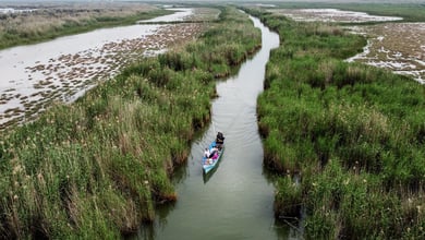
Eventually, many of Tabas’ landscapes have geological importance, while also being beautiful: Kalmard Box Folding, Darin Angular Unconformity, Derenjal Moutain, Permian, Peykuh Badland, Meander, Sorond Badland, Shotori Mountains, Khanik Paddy fields (with rice fields) and Nayband Mountains.
Geoarcheological geosites
On some of the geological geosites previously cited can be found four other sightseeing that are of major significances in terms of geoarcheology:
Kal-e Jenni and Kal-e Sardar Gabr Houses: these were houses carved in the walls of the valleys, in rows of horizontal and vertical cavities. They contain rooms and corridors. The roofs seem to indicate it dates back to the Safavid era but they could also have been Zoroastrians houses.
Korit Ancient Dam is the oldest, tallest (60 meters) and thinnest (1.5 meters) arched dam in the world.
Shah Abbasi Ancient Arch is also located on Kal-e Sardar. This dam is a masterpiece of engineering and creativity. It is 17 meters high and 3.35 wide.
Natural geosites
Tabas has two sites that are considered for geosites due to their natural importance. The first one is Nayban Wildlife Refuge, which is the most important habitat for Asian cheetahs. There are currently 13 to 16 cheetahs, an endangered species, in this area. Besides cheetahs, Naybadan also has an exceptional variety of plants (with 177 species) and animals.
The other natural geosite of Tabas is Senou Forest Habitat, which is home to a unique species of Fraxinus tree (“senou” in the local language).
Cultural and historical geosites
UNESCO geosites also include cultural and historical sites of major importance. In Tabas, 10 of them are considered as such. It’s the case for the Tabas Citadel, dating back from pre-Islamic times and used as a shelter in case of emergency or attack, the Water Reservoir of Koucheh Narenji, Ibn Musa-Al Kazem Holy Shrine (dating back from the 5th century AH), Golshan Garden, considered as one of the world’s most beautiful gardens, and Korit Sepordani Graves.

Tabas also includes the beautiful Chahar-Deh Caravansary, which was built in 1881 and has a 17-meters high windtower, and Kalmarz Caravansary, which is actually two caravansaries, one old and one new. The oldest one was built in 1219 AH and the new one was built 92 years later.
Eventually, three ancient villages are also unique for their architecture and the way they have been built: Korit Historical Texture, once an important city in the region, Esfahk Historical Texture, and Nayband Historical Texture, which once occupied a very strategic position in the Silk Road. If many of these sites were partly destroyed in 1978 by a major earthquake, they have been since renovated and rebuilt.