
Contents
From the Arctic to Meymand
In 2017, photographers Karim and Maria Sahai traded Arctic landscapes for southeastern Iran. They traveled from Meymand to the UNESCO-listed Lut Desert, inscribed in 2016 for its exceptional scenery and active geological processes under criteria (vii) and (viii). Their guest account and the photographs below document that journey, not recommended travel conditions today.


The following first-person account has been edited for clarity. It describes a past journey; reported temperatures are the travelers’ observations unless otherwise sourced. For more on the destination, see the Lut Desert guide.
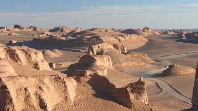
We had just finished leading a photography tour in Greenland and wanted a complete change of scenery. What could be more different from glaciers than photographing the kaluts, wind-sculpted formations of the Lut Desert? We traveled in August, when the heat made timing especially challenging.
We started in Meymand, where we spent a night among the village’s remarkable rock-cut homes.
Early the next morning, stocked with figs and peaches, we set out for the desert. As the heat rose, our guide stopped at an old qanat, an underground water channel, where we found brief shelter from the sun.
Photographing the wind-carved kaluts
We had come for the kaluts. These monumental ridges, also called yardangs, are shaped by wind erosion. Their scale made the landscape feel otherworldly.
We stopped only briefly to take photographs. Our cameras displayed high-temperature warnings, and our thermometer showed 54°C. This was a traveler’s observation, not a verified air-temperature record. Our guide limited the time outside the vehicle because of the extreme conditions.
Land-surface temperature versus air temperature
Heat fact-check: NASA reported a 70.7°C land-surface temperature in the Lut Desert in 2005. A satellite-measured ground-surface temperature is not the same as air temperature. See NASA’s explanation and the UNESCO listing. This archival account is not a recommendation to visit the desert in August; independent summer travel can be extremely dangerous.
See more of the photographers’ work through Full Life Photo Adventures on Instagram. The photographs remain in their original order. Their individual credits and reuse permissions require confirmation.
Photo essay: Meymand and the Lut Desert





Thank you for sharing our story. It was a great pleasure to travel in Iran.
We are very much looking forward to coming back!
Thank you so much for your feedback. We are looking forward to having you with us soon again! We really appreciate the nice words.